Selected Work Samples
Watch Them Segregate- Do STEM jobs exacerbate economic segregation in Commuter Zones
Graduate Thesis – Working paper
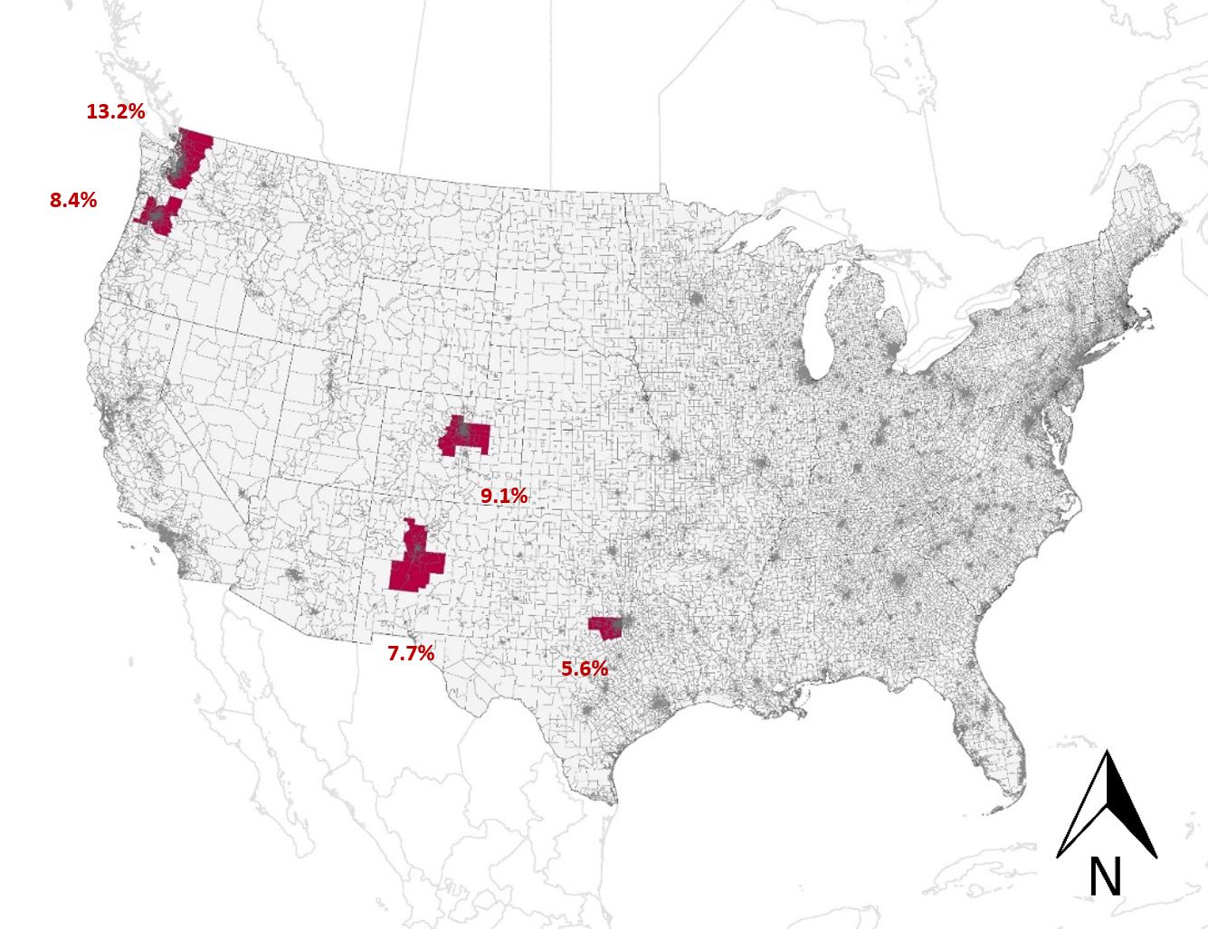
STEM workers have been touted as the economic drivers at local and federal level (Langdon, McKittrick, Beede, Khan, & Doms, 2011), and planners and policymakers often engineer policies for growth and economic development around their demand and supply. These individuals make 29 times more than their non-STEM counterparts (Langdon et al., 2011), and are consistently growing in numbers for the past 40 years (Watson, 2017). Therefore, it is essential to assess their impact on regional patterns. The thesis posits that STEM occupations drive patterns of economic segregation. To ascertain the validity of the phenomena, the study assesses the relationship between the concentration of individuals involved in STEM occupations and two measures of economic segregation; economic diversity and concentration of poverty. Upon analyzing the statistics at regional and census tract level for the five commuter zones, Seattle (WA), Portland (OR), Denver (CO), Albuquerque (NM) and Fort-Worth (TX), the study revealed mixed results. A secondary layer of spatial investigation was done to further explore the variability in the results.
Keywords: Economic Segregation, Spatial Analysis, Quantitative Analysis, Commuter zones
Research Document
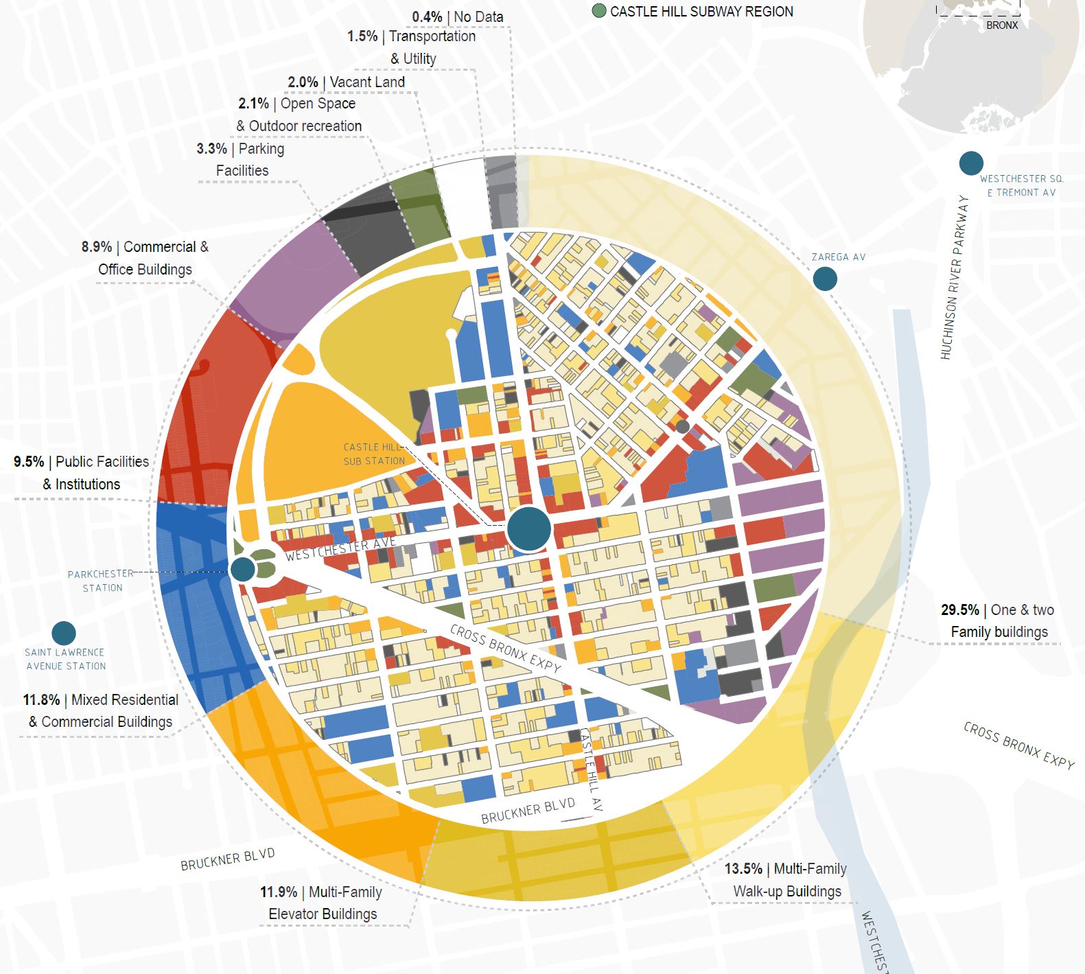
Unlocking East Brooklyn’s Affordable Housing Potential
Building Information Modeling
Mayor De Blasio of New York introduced the Mandatory Inclusionary Housing policy which intends to generate mixed income housing development in New York City. This Urban Model calculates the number of affordable housing units that are possible to generate within the East New York MIH boundary based on the calculated potential FAR. The project considers the plots zoned for housing or are vacant with FAR 6 or above and calculate the number of on-site and off-site affordable housing. We also notice that given the policy, majority of the housing generated will not on-site as East Brooklyn has a large stock of inexpensive vacant sites where developers will choose to locate their affordable housing. This nature of development goes against the initial intent of the policy.
Keywords: Affordable housing, East Brooklyn, New York, Building Information modeling
Research Document
Cost of Congestion-NYC
Building Information Modeling
Mayor Bloomberg and Mayor Bill De Blasio tried to propose a cost of congestion for New York. These proposals have been rejected by the community stakeholders often citing them as disproportionately disadvantageous for individuals living in outer boroughs. This research proposes a more radical strategy to impose a cost of congestion on New York roads which is dynamic, equitable and sustainable.
Keywords:Transportation, New York City, Cost of Congestion
Research Document
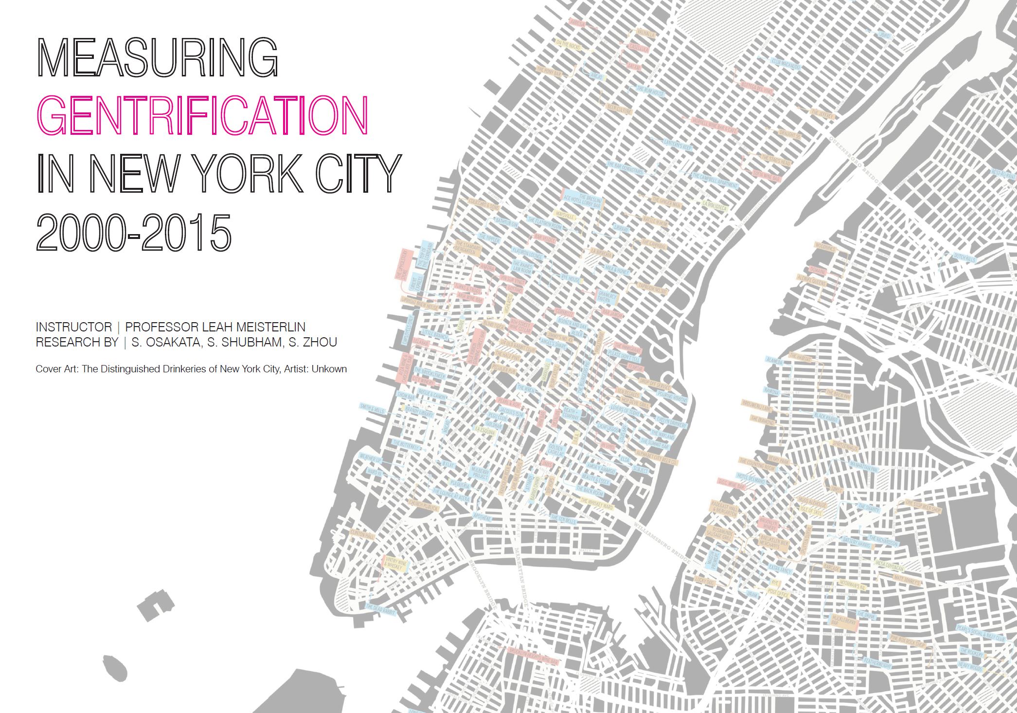
Measuring Gentrification
Advanced Spatial Analytics
The built environment is critical in determining the urban fabric of the city. The influences can include access to opportunities, social infrastructure, and location for economic transactions. The research using a wide range of tools as provided by ArcGIS formulates a model which predicts the areas within New York City that are gentrified based on the built environment. It also compares the analyses with gentrified areas as observed based on demographic attributes and demonstrates the level of accuracy with which how well the built environment of a neighborhood determines its degree of gentrification.
Keywords: Gentrification, Spatial Analysis, New York City
Research Document
GIS Portfolio - 2018
Advanced Spatial Analytics
This document is a compilation of all the exercises done by me during the intro to Geographic Information System and Advanced Spatial Analytics classes.
Keywords: ArcMap, ArcGIS, QGIS, Network Analysis, Cluster Analysis
GIS Portfolio
Testing for Open Space, Gangxia Urban Village, Shenzhen
Building Information Modeling
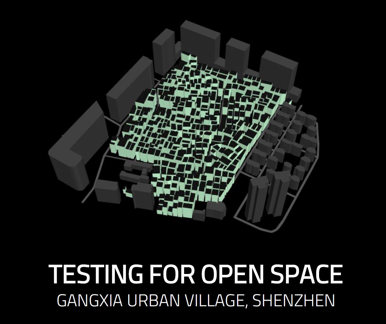
This study is analyzing the effect of open spaces within a dense urban fabric in the Urban Village of Ganxgia, located in Shenzhen, China. The model inputs a series of open spaces of varying sizes and redistributes the volume of residents while maximizing daylight received by individual households and façade length, which is considered as a proxy for economic opportunity. At the same time the model aims at minimizing the average height of the buildings. Each resident within the village maintains ownership of their home and hence cannot be displaced. Therefore, the model maintains the volume, such that all the residents can be accommodated within the proposed redistribution of built vs open spaces.
Keywords: Urban Village, Restructuring Spaces
Testing for Open Spaces
Studio Project - Brooklyn Wholesale Meat Market
Redevelopment Proposal
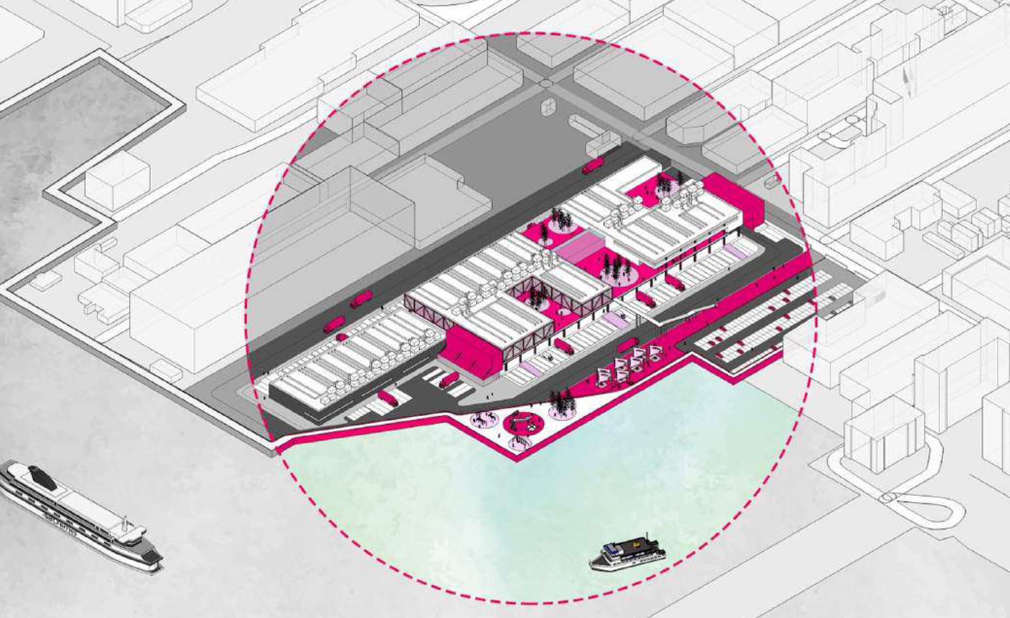
This document is a proposal for redeveloping the site of the Brooklyn Wholesale Meat Market. The BWMM is an industrial property owned by the city and managed by the New York City Economic Development Corporation (NYCEDC), located along the Sunset Park’s waterfront in Brooklyn, New York. It is a site NYCEDC intends to leverage the site for strategic redevelopment. The recommendations proposed here considers the needs of our client and the community. The proposal intends to reposition the Brooklyn Wholesale Meat Market into a food distribution and manufacturing hub called the Sunset Park Food Terminal. The Sunset Park Food Terminal will be a vibrant food manufacturing ecosystem that houses the existing wholesale tenants. It will also be the site for many new uses such as the co-packing, food incubator, step-up spaces, and a workforce training center. The idea is to build an environment where food businesses can thrive. The interventions will have a large positive impact with new food manufacturing and distribution jobs, additional open space, public access to the waterfront and permanent food manufacturing and distribution space.
Keywords: Industrial, Redevelopment, Resilience, Community Outreach
Redevelopment Proposal
Fort Lauderdale - Seawall Ordinance
Critique and Analysis
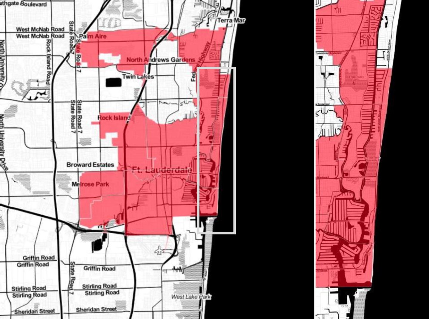
Cities such as Florida City, Miami, Fort Lauderdale and Miami Beach face constant threats to infrastructure, transportation systems, utilities and private property due to Sea Level Rise. In response to the crisis, the city of Fort Lauderdale proposed an ordinance in 2016 which regulates the construction and maintenance of seawalls. The city has 191 miles of private seawalls and only 4 miles of city-owned seawalls; thus, their maintenance was out of scope of the city agencies. The paper discusses the challenges in formulating the ordinance, building consensus among the stakeholders, critiquing the implementation and discussing it in context of other similar ordinances that have been implemented. With this ordinance, Fort Lauderdale embarked in the right direction in creating resilient settlements. However, there are many more strategies that they ought to employ to ensure the longevity of this thriving community. It has been able to devise an impactful legislature given the limited resources that they currently have. With more backing from federal and state agencies (as in the case of New Orleans) the city could provide more comprehensive and far-reaching solutions.
Keywords: Resilience, Qualitative Analysis, Fort Lauderdale
Paper
YUCCI Valley- Comprehensive Plan
Comprehensive Plan
This project is simulation of comprehensive planning effort for Yucci Valley, a small city assumed to be located near Ann Arbor and Michigan. It has a thriving agricultural economy and a rapidly growing tech-industry. With its population estimated to double in the next 20 years, the city needs to employ a comprehensive strategy to facilitate the smart growth and conserve existing agricultural and open spaces. Planning strategies include rethinking the transportation network, imposing zoning regulations, conserving historic districts and proposing more infrastructure facilities.
Keywords: Area-wide plan, zoning, land use analysis, transportation planning, infrastructure planning
Paper